
DCFR Insight 37 / Environmental + Physical Site Diligence
Land DevelopmentEnvironmental and Physical Due Diligence for Data Center Site Acquisition
Phase I and II environmental review, wetlands, floodplain, species, cultural resources, geotechnical conditions, grading, drainage, and remediation must be converted into usable land, approval, cost, schedule, and commercial decisions.

Environmental diligence is broader than a Phase I report
A Phase I Environmental Site Assessment addresses a defined contamination-liability purpose; it does not prove that the parcel is ecologically clear, geotechnically buildable, outside flood exposure, free of cultural-resource constraints, or able to secure every local, state, and federal approval. Build one integrated diligence program that separates environmental liability, regulated resources, natural hazards, physical ground conditions, civil constructability, and operational permitting—then shows how they interact with the campus plan and acquisition terms.
Use the applicable environmental-liability diligence basis
For U.S. acquisitions using the federal All Appropriate Inquiries framework, EPA identifies ASTM E1527-21 as consistent with the rule for commercial real estate and ASTM E2247-23 as an applicable option for forestland or rural property. That framework is not a universal environmental clearance, and other jurisdictions can impose different acquisition, disclosure, remediation, permitting, and continuing-obligation regimes. Define the governing legal basis, user, qualified professional, property, timing, access, prior reports, data gaps, recognized conditions, and non-scope business risks with counsel and the environmental consultant. No diligence opinion should be presented as a guarantee that contamination is absent.
Escalate Phase II work from a decision hypothesis
Target intrusive investigation at specific recognized conditions, data gaps, proposed high-consequence areas, and questions that change the transaction or campus. Define media, analytes, locations, depths, methods, access, health and safety, disposal, restoration, reporting, schedule, and decision thresholds before mobilization. Coordinate sampling with borings, demolition, tank or utility investigations, groundwater conditions, and future grading so separate programs do not create blind spots or conflicting data. The output should support avoidance, remediation, risk allocation, pricing, schedule, or exit.
Treat wetlands and waters as mapped approval geometry
Desktop data are an early screen, not a final boundary or jurisdictional conclusion. Obtain site-specific delineation and the appropriate agency pathway for regulated waters and wetlands, while also checking state and local protections that may extend beyond federal jurisdiction. Map direct and indirect effects from buildings, roads, transmission, pipelines, outfalls, grading, fill, crossings, and temporary construction. Show buffers, avoidance alternatives, mitigation assumptions, seasonal fieldwork, application dependencies, and the capacity and schedule consequence of uncertainty.
Separate mapped flood hazard from full climate and drainage exposure
FEMA's Flood Map Service Center is the official public source for National Flood Insurance Program flood-hazard information, but an acquisition decision may require more than the effective map. Confirm map status and datum, floodway, base-flood elevations, local overlays, drainage paths, upstream and downstream change, dam or levee context, historical events, access continuity, utility and substation exposure, finished-floor and freeboard requirements, compensatory storage, and future-condition or climate scenarios where relevant. A pad outside a mapped floodplain can still be operationally weak if its only road, power route, or outfall is exposed.
Integrated Site-Diligence Decision Matrix
| Workstream | What it proves | What it does not prove | Decision output |
|---|---|---|---|
| Phase I / All Appropriate Inquiries | Historical and current evidence relevant to recognized environmental conditions and applicable liability strategy | Absence of contamination or full development feasibility | Recognized conditions, data gaps, user obligations and Phase II or commercial actions |
| Phase II / targeted investigation | Conditions at defined sample locations, depths, media and analytes | Complete delineation unless scoped and supported accordingly | Avoidance, delineation, remediation, price, allocation or exit decision |
| Wetlands and waters | Site-specific resource limits and applicable agency pathway | All state and local constraints unless separately confirmed | Avoidance, crossing, mitigation, permit and capacity effect |
| Flood and drainage | Mapped hazard plus modeled or observed site-water behavior within the study scope | Guaranteed future access or operations under all events | Elevation, protection, redundancy, storage, outfall and rejection criteria |
| Species and cultural resources | Known or surveyed resources, consultation triggers and timing within scope | Clearance beyond the completed agency or jurisdictional process | Avoidance, survey, consultation, mitigation and seasonal schedule |
| Geotechnical and earthwork | Subsurface conditions at investigated locations and engineering implications | Uniform conditions across an untested campus | Foundation, grading, stabilization, dewatering, contingency and investigation plan |
Each conclusion is limited by scope, timing, access, sampling density, agency jurisdiction, and the quality of source information. Preserve those limitations in the acquisition decision.
Screen species and habitat early enough to change the plan
Use current agency information and qualified field expertise to identify listed or sensitive species, critical habitat, migratory or seasonal constraints, tree clearing windows, streams, habitat connectivity, and permit or consultation triggers. Tools such as the U.S. Fish and Wildlife Service's Information for Planning and Consultation system support early screening but do not replace required surveys or agency coordination. Overlay resources and timing restrictions with grading, access, utility routes, outfalls, laydown, and construction sequence.
Identify cultural-resource pathways before disturbance
Federal funding, permits, licenses, approvals, or assistance can create a Section 106 review obligation for undertakings with potential effects on historic properties; state, tribal, and local requirements may also apply independently. Determine the lead agency and consultation path with qualified counsel and cultural-resource professionals. Address records review, field survey, archaeological sensitivity, historic structures and landscapes, tribal coordination, avoidance, data recovery or mitigation, inadvertent discoveries, confidentiality, and seasonal access. Do not begin irreversible disturbance before the applicable process and authority are clear.
Make geotechnical and earthwork risk phase-specific
A few preliminary borings do not characterize a large campus. Develop an investigation plan around building pads, equipment yards, substations, tanks, roads, retaining conditions, stormwater facilities, deep utilities, transmission structures, and major cut-and-fill zones. Evaluate bearing, settlement, expansive or collapsible soils, rock, karst, groundwater, dewatering, liquefaction and seismic effects, corrosion, thermal properties where relevant, reuse of excavated material, import and export, stabilization, foundations, pavement, and seasonal construction. Connect findings to grading balance, structural concept, cost range, schedule, and additional investigation gates.
Reconcile environmental and civil work on one constraints plan
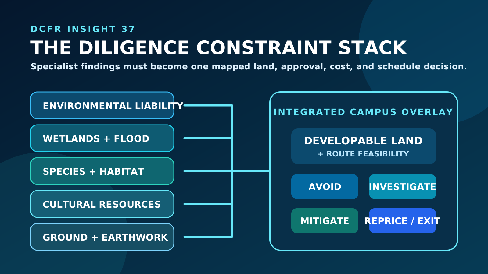
Contamination, wetlands, floodplain, habitat, cultural resources, unstable ground, steep slopes, drainage, outfalls, and title rights can overlap. Require georeferenced limits, source, date, confidence, jurisdiction, buffer or design criterion, allowed activity, confirmation action, and owner for every layer. Test the combined constraint stack against buildings, utilities, roads, security, fire access, stormwater, construction, and expansion. The integrated overlay—not separate consultant conclusions—defines developable acreage and route feasibility.
Convert findings into a risk-contained land recommendation
For each material issue, state the evidence maturity, plausible range, affected phase and capacity, approval path, investigation or mitigation duration, capital and operating effect, land right, responsible party, and commercial control. Identify seasonal or agency dependencies that can outlast the diligence period. The decision should distinguish acceptable residual risk from missing evidence and recommend advance, advance with conditions, targeted investigation, redesign, reprice, extend, remediate, or reject. More study is not a decision unless its question, deadline, threshold, and consequence are explicit.
Evidence-to-Action Escalation
| Evidence state | Example | Immediate action | Commercial posture |
|---|---|---|---|
| Desktop indication | Mapped wetland, historical industrial use, flood layer or habitat record | Field-verify and protect alternatives | Keep exit and extension rights; limit non-refundable exposure |
| Field observation | Staining, fill, wetland indicators, shallow groundwater or rock | Target qualified investigation and update the campus | Define access, testing rights, cost responsibility and milestone |
| Professional finding | Recognized condition, delineation, model or geotechnical recommendation | Quantify spatial, approval, cost and schedule effect | Negotiate cure, mitigation, price, allocation or condition |
| Agency pathway | Consultation, permit, mitigation or local approval requirements defined | Integrate predecessors and public or seasonal steps | Match option and closing dates to objective evidence |
| Resolved or contained | Accepted avoidance, completed remediation, permit, mitigation or priced residual risk | Transfer obligations into design, construction and operations | Advance under documented approval authority |
Current Technical Basis — August 2026
U.S. Environmental Protection Agency
Brownfields All Appropriate InquiriesEPA's current All Appropriate Inquiries guidance, including ASTM E1527-21 and E2247-23 references and reporting requirements.
Federal Emergency Management Agency
FEMA Flood Map Service CenterOfficial public source for flood-hazard information supporting the National Flood Insurance Program.
U.S. Army Corps of Engineers
Regulatory Program and PermitsOfficial overview of the Corps' regulatory program for activities affecting waters, including wetlands.
U.S. Fish and Wildlife Service
Information for Planning and ConsultationOfficial early-planning tool for species, habitat, and related environmental-review information.
Advisory Council on Historic Preservation
Section 106 Applicant ToolkitOfficial overview for applicants involved in the federal historic-preservation review process.
Technical basis reviewed August 2026. Cooling technology, equipment capability, vendor qualification, and industry guidance continue to evolve; project decisions should use the latest applicable manufacturer data and professional engineering analysis.
Capacity-delivery review checklist
What to verify before the next release gate.
- Environmental liability, regulated resources, hazards, ground conditions, and operational permits are treated as distinct but connected workstreams
- The Phase I scope, standard, user obligations, timing, data gaps, and non-scope risks are explicit
- Phase II work is tied to defined hypotheses, locations, thresholds, decisions, and commercial actions
- Wetlands, waters, buffers, flood exposure, access, outfalls, and utility routes are mapped together
- Species, habitat, seasonal survey, tree-clearing, and consultation constraints are identified
- Cultural-resource and tribal consultation pathways are confirmed before irreversible disturbance
- Geotechnical coverage reflects the full campus, major facilities, grading, groundwater, and future phases
- All constraints are georeferenced with source, date, confidence, jurisdiction, and confirmation action
- Seasonal and agency durations are tested against diligence, closing, and required-in-service dates
- The final recommendation distinguishes contained residual risk from missing decision-critical evidence
What DCFR would flag
Delivery risks that should be visible early.
A Phase I report is not a development-readiness certificate. DCFR would flag any environmental, flood, ecological, cultural, geotechnical, drainage, or remediation conclusion that is not translated into mapped usable land, approval path, cost, schedule, capacity, and commercial control.
Professional confirmation required
Items requiring project-specific validation.
Confirm the governing jurisdictional basis for environmental liability, assessment standards, recognized conditions, sampling, wetlands and waters, flood criteria, species, cultural resources, Indigenous or tribal consultation, geotechnical conditions, permits, mitigation, remediation, cost, schedule, and continuing obligations with qualified counsel, licensed professionals, agencies, authorities, and the project owner.
Final takeaway
Diligence creates value only when specialist findings become a spatially coordinated, evidence-graded, commercially contained land decision.
Surface site, code, utility, and delivery risk before it becomes expensive.
DCFR converts early assumptions into planning-grade flags, confirmation registers, and decision-ready feasibility outputs.