
DCFR Insight 28 / Data Center Strategy + Site Diligence
Site ReadinessWhat Makes an Ideal Data Center Site?
A first-principles acquisition and diligence framework for proving that power, fiber, land, cooling, access, hazards, entitlements, off-site infrastructure, community conditions, and expansion can produce an executable path to capacity.

The Ideal Site Is Not a Place. It Is an Executable Evidence Package
The phrase 'ideal data center site' often collapses into a list of attractive characteristics: large acreage, nearby transmission, fiber, water, industrial zoning, low taxes, or favorable climate. That is not enough. A site is genuinely strong when the critical assumptions can be converted into documents, routes, dimensions, dates, counterparties, and decision rights. Power needs a credible delivery path and schedule. Fiber needs physical route diversity. Land needs a real buildable envelope. Cooling needs a viable thermal and water strategy. Access needs to support construction, emergency response, operation, and replacement. Entitlements need a plausible approval path. Future capacity needs protected land and infrastructure corridors. The ideal site is therefore the site with the fewest unowned assumptions between site control and energized IT capacity.
Do not underwrite attributes. Underwrite evidence, dependencies, and time to usable capacity.
Keep Insight 28 Separate From Campus Master Planning
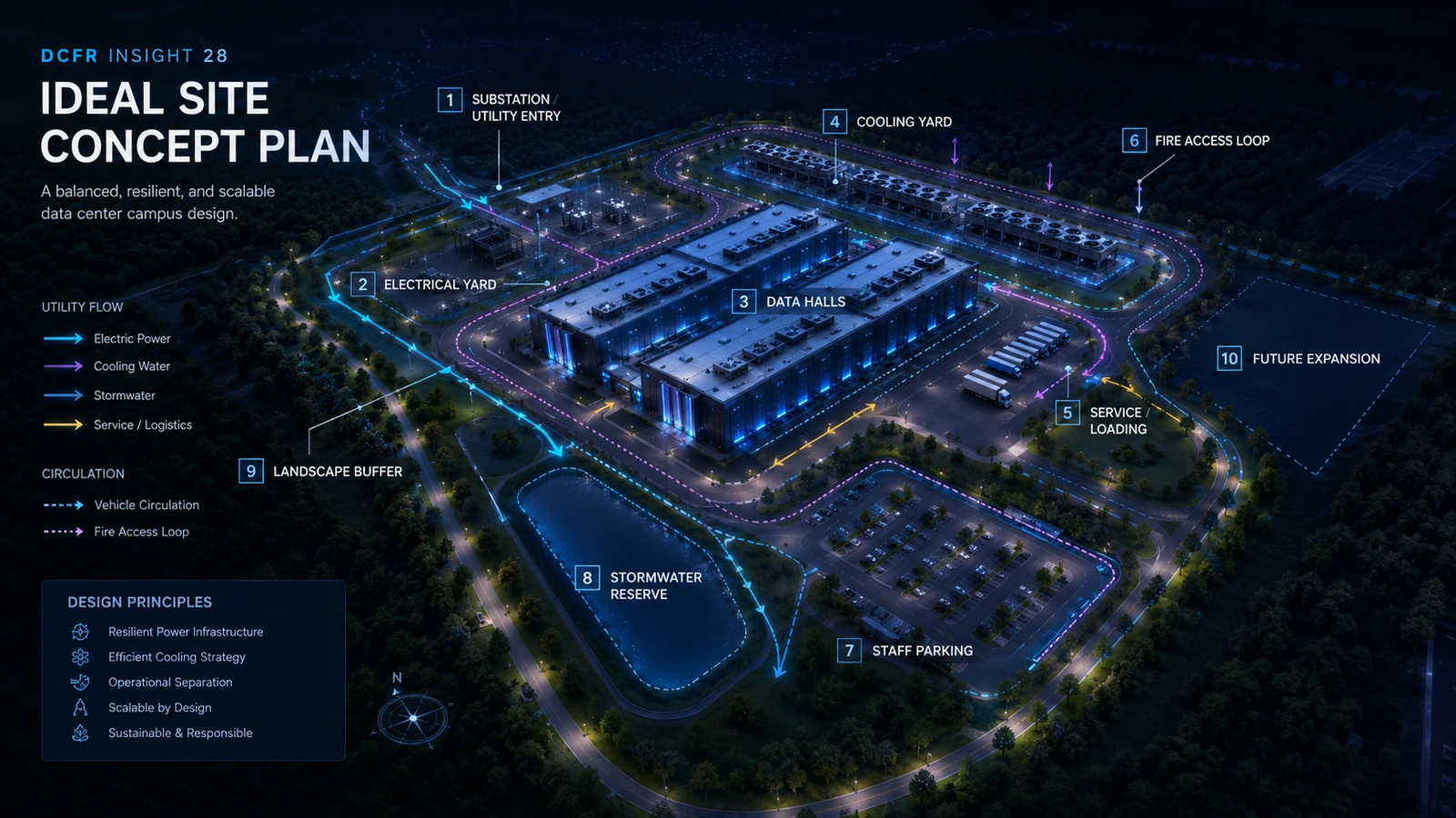
Insight 24 addresses how to lay out and phase a multi-building campus. Insight 28 addresses the decision that comes before that: whether the land should be controlled, purchased, or advanced at all. The concept plan is used here only as a diligence test. It asks whether the required buildings, utility entry, electrical yards, cooling, roads, fire access, stormwater, buffers, construction logistics, and expansion can physically coexist. The objective is not to optimize the final campus; it is to expose assumptions that could invalidate the investment before deeper design begins.
Use planning geometry to test the acquisition thesis—not to pretend the campus is already designed.
Ten Non-Negotiables for a Site-Readiness Scorecard
A practical scorecard should separate pass/fail gates from weighted preferences. A fatal issue should not disappear because the parcel scores well on nine other categories.
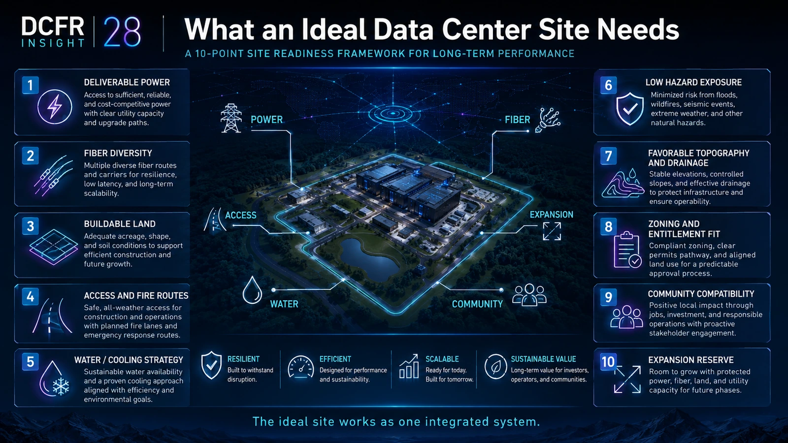
- 1
Deliverable power
Identify the serving utility, point of interconnection, credible capacity, voltage, off-site work, utility milestones, cost responsibility, phasing, and earliest plausible energization date.
- 2
Fiber diversity
Confirm carriers, route geography, physical entry separation, latency needs, easements, and whether two nominal connections actually share the same upstream path.
- 3
Buildable land
Convert gross acreage into net usable land after setbacks, easements, flood constraints, wetlands, steep slopes, drainage corridors, utility corridors, buffers, and access requirements.
- 4
Construction and emergency access
Prove heavy-haul, crane, fire-apparatus, fuel/service, worker, and future equipment-replacement access from the public road system to the intended campus areas.
- 5
Cooling and water strategy
Match workload density and climate to a realistic heat-rejection concept, then confirm water source, quality, discharge, drought mode, electrical penalty, noise, plume, and land demand as applicable.
- 6
Hazard exposure
Screen flood, wildfire, seismic, severe weather, extreme temperature, water stress, and other project-relevant hazards using current authoritative sources and site-specific investigation.
- 7
Topography, drainage, and soils
Test whether a practical building pad and infrastructure grades can be created without excessive cut/fill, retaining walls, drainage complexity, or geotechnical risk.
- 8
Zoning and entitlement path
Identify allowed use, development standards, discretionary approvals, public-hearing exposure, fire/code review path, environmental review, off-site conditions, and the agencies that can affect schedule.
- 9
Community compatibility
Map residential, school, park, cultural, ecological, traffic, noise, water, visual, and emergency-service interfaces before assuming entitlement risk is low.
- 10
Expansion reserve
Protect future land, utility capacity, fiber, cooling, road, construction, stormwater, and replacement corridors rather than labeling leftover acreage as future expansion.
Ideal-Site Readiness Matrix
| System | Evidence to seek | Hold / no-go trigger |
|---|---|---|
| Power | Utility-specific capacity, point of interconnection, off-site scope, milestones, timing | No credible path to required power by business-critical date |
| Fiber | Carrier routes, physical diversity, entry points, latency basis | Required diversity depends on shared physical route or unavailable easement |
| Land | Survey/title, buildable envelope, constraints, coherent pad geometry | Net geometry cannot fit complete capacity and support systems |
| Cooling / water | Thermal options, climate basis, water source/quality/discharge, peak-mode feasibility | Capacity depends on unavailable water or unverified heat rejection |
| Access | Heavy-haul route, fire/service circulation, replacement path | Critical equipment cannot reach or later be replaced on site |
| Hazards | Authoritative screening plus specialist follow-up where material | Unmitigable risk or unacceptable schedule/cost consequence |
| Entitlements | Allowed-use analysis, agency map, approvals, studies, hearing path | Use cannot be approved within acceptable risk/time |
| Community | Sensitive receptors, noise/light/traffic/water issues, engagement risk | Required mitigation materially undermines capacity or schedule |
| Expansion | Protected land and utility/circulation corridors | Future capacity depends on unavailable land or blocked infrastructure |
Power: Replace 'Near Transmission' With a Utility Evidence Ladder
Proximity to a substation or transmission line is not proof of deliverable power. Site diligence should progressively move from public information to utility contact, preliminary capacity discussions, load study or equivalent utility process, point-of-interconnection definition, required substation or transmission work, land and easement requirements, commercial responsibility, milestone schedule, and contractual commitment where available. The exact process varies by utility and market, but the underwriting rule does not: each stage should reduce uncertainty. A site whose power story depends on a marketing map should remain high risk even if the line is visible from the parcel.
The power score improves when the evidence becomes more contractual, site-specific, and time-bound.
Fiber: Route Diversity Must Be Physical, Not Just Commercial
Two carriers do not automatically create resilient connectivity if both use the same conduit, bridge, railroad crossing, street segment, or upstream facility. Diligence should map carrier points of presence, long-haul direction, local laterals, rights-of-way, parcel entry points, building entry points, and shared physical dependencies. Where latency is commercially important, test the actual network requirement rather than assuming metropolitan proximity is sufficient. Preserve at least the planning geometry for physically diverse entries before buildings, substations, or stormwater consume the only viable routes.
Land: Gross Acres Must Be Reconciled to a Buildable Envelope
A credible site-fit study starts with survey and title information when available, then layers setbacks, easements, flood hazards, wetlands and environmental constraints, topography, drainage, roads, utility corridors, buffers, stormwater, and future expansion. The remaining shape matters as much as its area. A fragmented 100-acre buildable envelope can be worse than a compact 70-acre one. The feasibility output should therefore show gross acreage, estimated constrained acreage, net planning acreage, the largest coherent development pad, and the principal conditions that could shrink that pad during further diligence.
Acreage becomes useful only after the site proves a coherent place for complete capacity blocks and their support infrastructure.
Cooling and Water: Do Not Pick a Site Around a Generic Cooling Assumption
High-density Artificial Intelligence (AI) workloads, direct-to-chip liquid cooling, air cooling, evaporative systems, dry coolers, cooling towers, hybrid systems, and heat-reuse concepts can produce very different electrical, water, acoustic, land, and operational consequences. Site diligence should therefore compare plausible thermal architectures against local design conditions and resource limits. Ask whether water is available in the quantity and quality required, whether discharge is feasible, what happens during drought or restrictions, how much land heat rejection occupies, where noise travels, and what the electrical penalty is in peak conditions. A site that works only under one unverified cooling assumption should be marked conditional rather than ready.
Hazards: Use Authoritative Mapping as a Screen, Then Escalate to Site-Specific Investigation
In the United States, the Federal Emergency Management Agency Flood Map Service Center is the official public source for National Flood Insurance Program flood-hazard information, but a feasibility decision should not stop at one map layer. Flood risk, wildfire, seismic conditions, wind, severe weather, extreme heat or cold, water stress, and site-specific drainage can affect both capital and operating resilience. The diligence register should state the source, date, mapping status, known limitation, and next confirmation action. Where risk is material, specialist studies should replace planning assumptions before acquisition contingencies expire.
A hazard layer is an early warning system—not a substitute for project-specific engineering and environmental diligence.
Access: Trace the Largest Object and the Worst Day
Normal passenger-car access is the least demanding circulation test. Follow the path of a transformer, generator, chiller or cooling module from regional road to final installed location. Test bridge limits, turning geometry, gate width, grades, overhead clearances, staging, crane positions, and future replacement. Then test the worst emergency day: fire apparatus, security response, blocked routes, construction activity, fuel or service traffic, and weather. The site should also preserve a separate logic for later phases so future construction does not repeatedly cross live secure operational zones.
Entitlements and Community: Identify the Decision-Makers, Not Just the Zoning Label
Industrial zoning may be encouraging but still leave discretionary approvals, special-use permits, design review, environmental review, utility or road conditions, noise limits, water restrictions, or public-hearing risk. Diligence should identify every agency and governing body with a meaningful decision, the sequence of those decisions, required studies, public-notice points, likely off-site commitments, and the issues most likely to attract community attention. A realistic approval schedule includes time to revise, negotiate conditions, and respond to comments—not just statutory minimum review periods.
Expansion: Reserve Infrastructure Corridors Before Reserving Buildings
Future expansion is not simply an empty rectangle. It requires future power and utility routes, fiber, cooling or heat rejection, roads, fire access, stormwater, construction laydown, crane and replacement access, security transitions, and potentially additional substations or water infrastructure. The first phase should not consume the easiest corridors and leave later capacity technically possible but operationally awkward. At diligence stage, the test is simple: draw the protected corridors and explain how Phase 2 reaches them without dismantling Phase 1.
Build a Fatal-Flaw Register Before a Weighted Scorecard
Weighted scoring is useful only after critical failure conditions are visible. Establish explicit fatal or hold conditions such as no credible power delivery path by the required date; insufficient buildable geometry; unresolved flood or environmental constraint; no heavy-haul access; no viable cooling/water strategy; incompatible land use; no diverse fiber solution where required; or expansion that depends on land or infrastructure outside the controlled site. Each item should be labeled Pass, Conditional, Hold, or No-Go with evidence, owner, next action, and deadline. This prevents attractive secondary attributes from masking a fundamental capacity-delivery problem.
Diligence Decision Gate
| Status | Meaning | Required action |
|---|---|---|
| PASS | Evidence is sufficient for the current decision stage | Advance while tracking normal confirmation items |
| CONDITIONAL | Site can advance if a named assumption is confirmed | Assign owner, evidence requirement, deadline, and fallback |
| HOLD | Material uncertainty can change capacity, cost, or schedule | Do not increase commitment until the issue is resolved |
| NO-GO | Fatal condition prevents an acceptable delivery pathway | Exit, renegotiate, or fundamentally change the project brief |
Tie Site Control to Diligence Exit Conditions
The strongest commercial structure preserves the ability to exit or reprice while the highest-risk assumptions are tested. The specific legal structure belongs to counsel, but the development team should define the technical conditions it needs before non-refundable commitment: survey/title resolution, utility milestone, environmental status, geotechnical findings, access rights, fiber pathway, entitlement status, water/cooling confirmation, and a planning-grade site fit. The dates for those conditions should be aligned with option periods, extension rights, deposits, and investment approvals. Diligence is valuable when it changes the decision before capital becomes trapped.
A good diligence program converts uncertainty into explicit commercial decision points.
Use a 30 / 60 / 90-Day Diligence Rhythm
Actual durations vary, but the work benefits from deliberate sequencing. The first period should expose fatal flaws quickly: site control documents, utility engagement, flood/environmental screening, zoning path, access, high-level site fit, and fiber. The second period should deepen the critical systems through surveys, geotechnical/environmental work, utility studies, cooling/water analysis, civil concept, entitlement pre-application, and initial cost/schedule. The third period should close the remaining decision gaps, update the integrated site-fit model, align commercial obligations, and issue the final recommendation. Do not wait for every report to finish before escalating a fatal issue; the purpose is decision speed, not document accumulation.
The Final Output Should Be a Decision Record
A professional feasibility conclusion should not end with 'the site appears feasible.' It should state: the target capacity and date; the current site verdict; fatal flaws; conditional assumptions; the physical site-fit basis; utility and fiber status; cooling/water basis; entitlement and hazard exposure; expansion logic; cost/schedule range where developed; confirmation owners; and the exact events that would change the verdict. That record becomes the bridge from site acquisition to consultant procurement and campus design without pretending planning-grade diligence is final engineering.
DCFR Design Principle
If a site were chosen from zero, the goal would not be the cheapest parcel, the largest acreage, the coldest climate, or the nearest transmission line. The goal would be the lowest-friction executable pathway from land control to resilient IT capacity, with enough evidence to understand what is real, what is assumed, and what still needs confirmation.
SELECT THE SITE WITH THE STRONGEST EVIDENCE-BACKED PATH TO CAPACITY—NOT THE STRONGEST MARKETING STATISTIC.
Current Technical Basis — August 2026
Federal Emergency Management Agency
Flood Map Service Center and National Flood Hazard Layer GuidanceU.S. Green Building Council
Applying LEED to Data Center ProjectsTechnical basis reviewed August 2026. Cooling technology, equipment capability, vendor qualification, and industry guidance continue to evolve; project decisions should use the latest applicable manufacturer data and professional engineering analysis.
Capacity-delivery review checklist
What to verify before the next release gate.
- Define the target IT capacity, density, resilience level, phasing, and required energization date before scoring land.
- Use a fatal-flaw register before weighted scoring so critical failures cannot disappear inside averages.
- Replace 'near power' with utility-specific evidence, milestones, off-site scope, and timing.
- Map physical fiber route diversity rather than counting carrier names alone.
- Reconcile gross acreage to a coherent buildable envelope after real constraints and infrastructure reservations.
- Trace heavy equipment, fire/service access, and future replacement from public road to final position.
- Tie site-control and investment decisions to named technical diligence exit conditions.
- Issue a final decision record stating what is confirmed, assumed, conditional, and capable of changing the verdict.
What DCFR would flag
Delivery risks that should be visible early.
DCFR would flag a site marketed as 'ready' when its headline capacity still depends on speculative power, shared fiber routes, gross rather than buildable acreage, unverified cooling/water assumptions, unresolved entitlement decisions, or future expansion without protected infrastructure corridors.
Professional confirmation required
Items requiring project-specific validation.
All utility capacities and dates, fiber routes, title/survey conditions, flood and environmental constraints, geotechnical conditions, water availability, cooling systems, access, entitlements, costs, schedules, and legal site-control terms require project-specific confirmation by the owner, utilities, authorities having jurisdiction, counsel, and qualified design and technical professionals.
Final takeaway
THE IDEAL DATA CENTER SITE IS THE ONE WITH THE FEWEST UNOWNED ASSUMPTIONS BETWEEN SITE CONTROL AND ENERGIZED IT CAPACITY.
Surface site, code, utility, and delivery risk before it becomes expensive.
DCFR converts early assumptions into planning-grade flags, confirmation registers, and decision-ready feasibility outputs.